
By Ahmed Mohamed Ismail & Farah Jama Farah.
Access to safe, reliable water remains a fundamental challenge in Somalia’s arid regions. Recent assessments show recurring shortages and high pressure on limited groundwater resources especially in fast-growing towns such as those in Puntland underscoring the need for smarter, evidence-based groundwater planning.
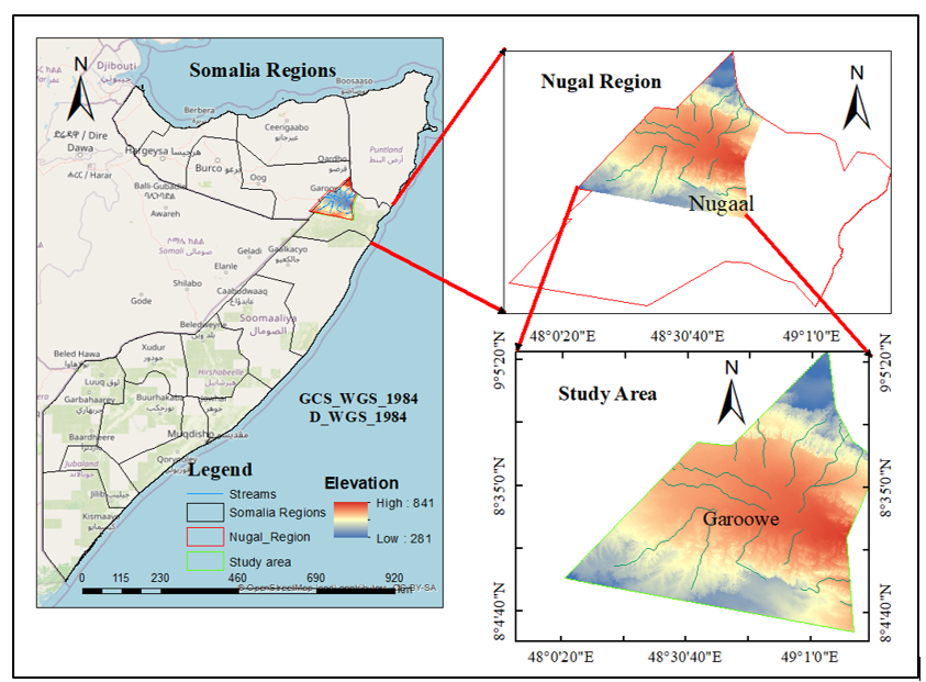
Figure 1: Location of the study area. Map showing Somalia, the Nugal Region, and Garowe District with elevation background, situating the study area within the national and regional context.
What We Studied
Our work (soon to be published internationally) applies remote sensing (RS), Geographic Information Systems (GIS), and the Analytical Hierarchy Process (AHP) to identify Groundwater Potential Zones (GWPZs) across Garowe District Puntland – Somalia. This integrated geospatial + multi-criteria decision approach is widely used in groundwater prospecting and resource planning, with many peer-reviewed studies reporting strong performance in diverse terrains.
How the Method Works (in brief)
We created nine thematic layers known to influence groundwater occurrence—rainfall, lineament density, geology, slope, soil, land use/land cover (LULC), drainage density, vegetation (NDVI), and elevation—and combined them using an AHP-based weighted overlay. This systematic method ensures that factors are considered according to their relative importance.
Drainage density is a critical factor, as areas with low drainage density often have higher groundwater recharge potential.
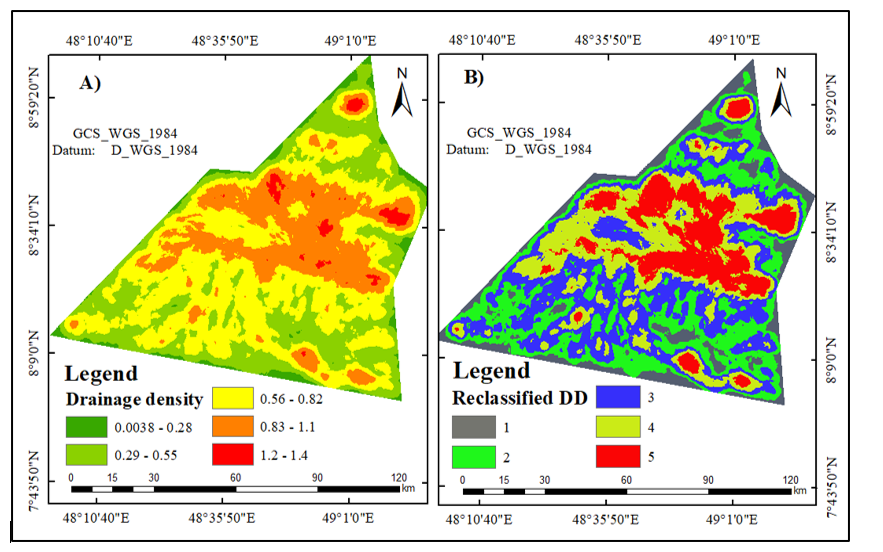
Figure 2: Drainage density map of Garowe District. (A) Drainage density distribution. (B) Reclassified drainage density used in groundwater potential analysis.
Land use and vegetation cover also play a major role. Vegetated areas encourage infiltration, while built-up and barren areas can limit recharge.
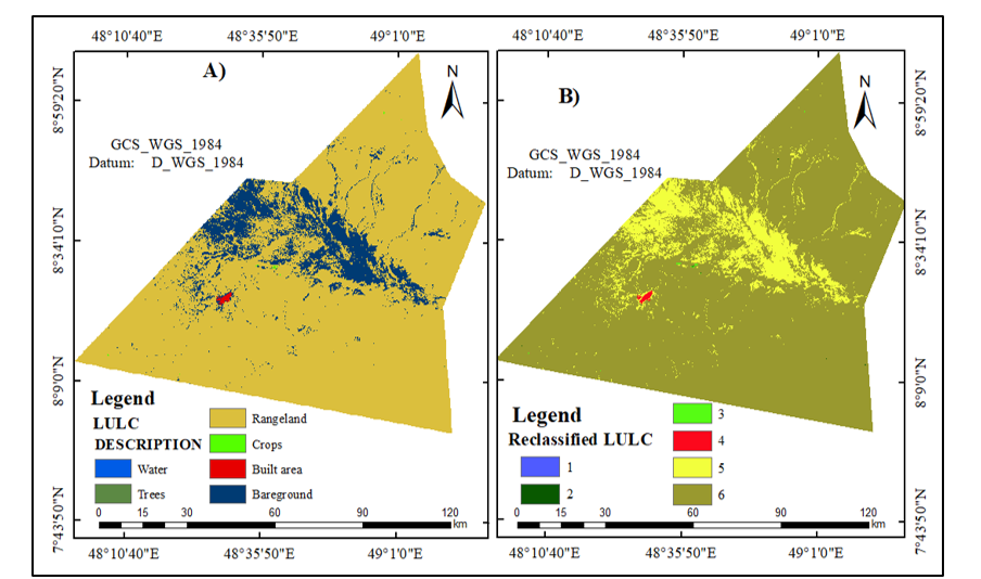
Figure 3: Land Use/Land Cover (LULC) map of Garowe District. (A) Original LULC classification showing rangeland, crops, water, built-up area, trees, and bare ground. (B) Reclassified LULC applied in the groundwater potential mapping.
Elevation influences both surface runoff and groundwater accumulation. Lower and gently sloping areas generally allow more infiltration, making them favorable for groundwater occurrence.
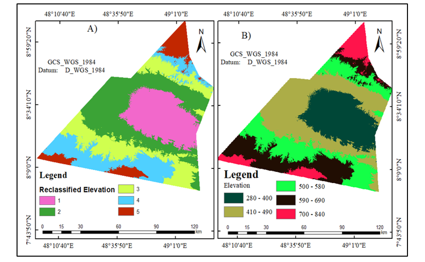
Figure 4: Elevation map of Garowe District. (A) Reclassified elevation. (B) Original elevation classes (meters above sea level).
Our Results (Garowe)
The model classified Garowe’s groundwater potential into five categories:
- Excellent – 7.8%
- Very Good – 28.1%
- Good – 27.5%
- Poor – 23.4%
- Very Poor – 12.5%
To test accuracy, we validated the map against 50 existing water points (springs, hand-dug wells, and boreholes). The results achieved 80% accuracy and a Kappa coefficient of 0.74, confirming strong reliability compared to international benchmarks.
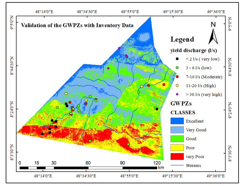
Figure 5: Groundwater Potential Zones (GWPZs) map with validation. Groundwater potential classes (Excellent, Very Good, Good, Poor, Very Poor) validated with inventory data from springs, hand-dug wells, and boreholes, showing yield discharge rates (l/s).
Why This Matters for Somalia
Somalia’s data scarcity has historically constrained water planning. RS/GIS + AHP methods provide cost-effective, scalable mapping that complements field surveys exactly what initiatives like FAO SWALIM and recent regional groundwater studies recommend to guide siting, drilling, and monitoring. Humanitarian and development actors are already scaling groundwater monitoring and climate-resilient boreholes in Puntland and beyond, reinforcing the need for targeted, evidence-driven siting tools like GWPZ maps.
Practical Uses
- Prioritize drilling sites: Focus primary investigation in “Excellent/Very Good” zones; use “Good” zones as secondary targets. (This mirrors site-selection frameworks in comparable AHP/RS studies.)
- De-risk investments: Use the map as a preliminary screening tool to reduce dry-hole risk before commissioning geophysical surveys. (Comparable projects report higher success rates when RS/GIS screens precede drilling.)
- Plan recharge & protection: Couple high-potential areas with land-use controls and recharge interventions to protect aquifers. (Land cover/NDVI’s influence on recharge is well-documented.)